
With two weeks to go, the only weather worth watching is the National Hurricane Center:
http://www.nhc.noaa.gov/index.shtml
Tropical Storm Rina has just developed. The good news about her is that the NHC and many great meteorologists will be watching her. I really like Jeff Masters' blog site:
http://www.wunderground.com/blog/JeffMasters/
November is the transition time between the hurricane season and the season of winter gales. Oh joy. Choose your poison. Since hurricane tracks are monitored and predicted so well, and since you don't go out there when one is lurking anywhere in the region, I'll take earlier (late October) over later (late November/December). Of course nasty Caribbean hurricanes can still wreak havoc well into November--but we know where they are for many days in advance. By mid November (sometimes mid October), it is typical to see a parade of intense low pressure areas pop off the coast near Hatteras and stir nasty conditions. Having directly experienced this in three prior late October trips to Virginia, that's why I sailed Heron to Hampton in gorgeous early October conditions. Finding a weather window to cross this parade of Mack- truck lows can be very unsettling. Encountering them can break ribs, blow in ports and tatter sails. (Just ask some of my friends.) The insurance companies, in their armchair wisdom, bottle up the fleets in east-coast ports until after November 1. IMHO, they should require their insured boats to hire a weather router (cheap insurance regardless) and allow them to leave when they want to, possibly no earlier than October 1. Some of my heartier friends who annually sail non-stop from Buzzards Bay to the BVIs in December might disagree. The boat can surely take a beating, but I am way too old for bungee jumping with the boys.
When we get within about T-10 days, I'll start watching Passage Weather, which is a slick on-line way to animate the GFS and the shorter range NAM weather models:
http://www.passageweather.com/index.htm?http%3A//www.passageweather.com/maps/bermuda/mappage.htm
http://www.passageweather.com/index.htm?http%3A//www.passageweather.com/maps/bermuda/mappage.htm
I'll get tuned in to how the major weather systems are moving by looking at the surface analysis sites:
http://www.weather.bm/charts.asp
http://weather.noaa.gov/fax/marsh.shtml#SFC
I download the grib version of the GFS model and animate it forward in time using Raymarine RNS software. This is the same as what you see on Passage Weather. When the departure date approaches, to see an example of a wind-based optimal route, I run the optimal routing tool using the rhumb line route, the polar performance data for Heron (that predicts boat speed for different wind angles and wind speeds), and this GFS grib model (that gives wind speed and direction along the route for the next 7 days or so). As in the Marion-Bermuda Race, I'd never strictly follow a route that is purely based on weather and boat models. However it is nice to have a silent virtual navigator looking over your shoulder to suggest how to set up the course to take advantage of predicted future changes. It's fun to animate optimal routes while you are waiting for the real thing. When the sails go up, it's time to sail the boat and put the games away.
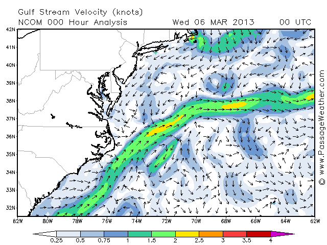
It's fun to look at the various Gulf Stream websites:
http://www.passageweather.com/maps/bermuda/ncom/000.png
http://rads.tudelft.nl/gulfstream/
http://marine.rutgers.edu/cool/sat_data/?product=sst®ion=gulfstream¬humbs=0
We will inevitably cross the Gulf Stream somewhere off of Hatteras, a NE-flowing river maybe 30-50 nm across. We'll cross it as quickly as possible, hopefully headed SE. If there is a significant eddy south of the stream (a large rotating region of surface water that is colder than its surrounding warm Sargasso Sea water), then we'll consider avoiding the unfavorable semi-circle. This isn't a race, so the consideration is really about making good time while avoiding nasty seas. For example, if we are surfing downwind in 30 knots of wind, it wouldn't be a good thing to wander into head-currents from an eddy that are flowing against that wind. Such seas are very steep and irregular --not fun. But the chances of this are slight since we'd only be a day or two out of Hampton and we'll know where they are.
OK. I admit I'm blathering. But it's my blog (and I can blog if I want to). Actually I'm sitting at Needham High, waiting for students to come in for math tutoring. But the end of the term isn't near, so desparation has not yet struck.... so I'mbored and typing away... hoping TS Rina will go away.
Jay
No comments:
Post a Comment